- What we know about the Highway 18 rockfall crash near Big Bear Lake
- When and where it happened, and who responded
- Weather context and why rockfalls happen in our mountains
- Injuries, impacts, and what families often face after a mountain highway crash
- How to get official records and public documents
- Insurance considerations after a rockfall related car accident
- Legal context: potential liability in rockfall triggered collisions in California
- Documenting the scene and follow up steps that can help later
- Road conditions, closures, and safety resources locals actually use
- Community contacts: who to call in and around Big Bear Lake
- Why timely action matters after a mountain highway incident
- Commentary from Gosuits Big Bear Lake, California Personal Injury Attorney
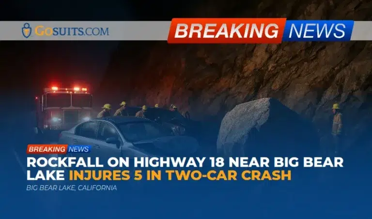
What we know about the Highway 18 rockfall crash near Big Bear Lake
Five people, including two children, were hurt in a two vehicle collision after a large boulder broke loose from the mountainside and rolled onto State Route 18 near Big Bear Lake. According to initial public safety reports, the crash happened around 5:45 p.m. near mile marker 44, west of the lake. Fire agencies reported that four of the five people were transported to area hospitals and that all reported injuries were considered minor at the time. Crews reopened the highway a few hours later after moving the boulder with help from Caltrans personnel. Local fire agencies from Big Bear Lake and Arrowbear assisted on scene.
This stretch of SR 18 is a lifeline between the high desert, Running Springs, and the Big Bear Valley. Residents know the switchbacks near the Arctic Circle section and the approach toward Big Bear Dam can be unforgiving in winter weather. When rockfall occurs, traffic can stop abruptly, and secondary collisions can follow within seconds.
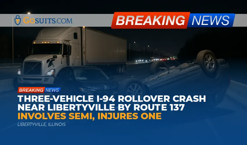
When and where it happened, and who responded
The incident occurred Friday evening near mile marker 44 on Highway 18, just west of Big Bear Lake. Darkness, recent winter storms, and mountain terrain likely made the situation more challenging for drivers and first responders. San Bernardino County Fire crews described the boulder as having “cleaved” from the mountainside before landing in lanes and contributing to the two car crash. Caltrans crews supported the clearance and the highway was reopened after the obstruction was removed. Big Bear Lake and Arrowbear Lake firefighters assisted with medical care and traffic safety while the scene was stabilized.
In the San Bernardino Mountains, initial traffic incident handling on a state route like SR 18 often involves the California Highway Patrol, Caltrans District 8, and fire agencies from nearby communities such as Big Bear Lake, Fawnskin, Arrowbear, and Running Springs. The coordination among these agencies is routine during winter storms when chain controls, rockfall, and spin outs can overlap.
Weather context and why rockfalls happen in our mountains
The crash followed days of stormy weather across Southern California. Winter storms can saturate steep slopes, loosen fractured rock, and send debris onto roadways. The phenomenon is well documented in mountainous regions: freeze thaw cycles, heavy rainfall, and runoff can destabilize slopes and trigger rockfalls.
Federal and scientific agencies offer helpful background on why rockfalls occur and how they can follow storms:
- USGS rockfall basics. The United States Geological Survey explains that rockfalls often occur on steep slopes where joints and fractures in rock masses allow blocks to detach, and that precipitation and weathering are common triggers. See USGS overview on rockfalls at usgs.gov.
- Weather related crash risk. The Federal Highway Administration notes that weather contributes to a significant portion of traffic crashes nationwide, especially during precipitation and on wet pavement. See FHWA road weather statistics at dot.gov.
Locally, anyone who drives SR 18 in winter knows to expect surprises after major storms. Snowmelt during the day can refreeze at night. Rock and ice can drop from cut slopes. Debris flows can carry gravel into curves near the Arctic Circle and the dam.
Injuries, impacts, and what families often face after a mountain highway crash
Thankfully, officials described the injuries in this event as minor. Even so, crashes triggered by a sudden obstruction often lead to head and neck strains, bruising, airbag abrasions, and anxiety about driving the mountain again. Children can present subtle symptoms that surface a day or two later. It is common for people to feel sore the next morning once adrenaline fades.
Beyond physical injuries, families frequently cope with damaged vehicles, lost workdays, and the logistics of towing from the mountain down to Highland or San Bernardino. In winter, body shops are backed up and rental cars are scarce. Phone calls with insurers can be confusing, particularly when multiple vehicles were involved and a rockfall is the initial cause.
When the event involves a rockfall and a chain reaction, the insurance questions get complicated quickly. Was the initial impact with the boulder, or a subsequent collision with another vehicle? Which coverage applies if the first contact is with debris? These are common questions after a mountain highway car accident.

How to get official records and public documents
Accurate records help families understand what happened and protect their rights. Here are typical records and how to request them in San Bernardino County and statewide:
California Highway Patrol collision report
CHP generally investigates crashes on state highways like SR 18. Request a copy of the collision report using form CHP 190 via the California Highway Patrol. Instructions and the request form are available through CHP’s website at chp.ca.gov. Reports usually become available within several days to a few weeks, depending on the investigation.
Caltrans incident and road information
For lane closures and traffic conditions at the time of the event, Caltrans provides live and historical road information through QuickMap at dot.ca.gov. Caltrans also publishes winter driving guidance and chain control information at dot.ca.gov. If you need records beyond public pages, a California Public Records Act request to Caltrans District 8 may be appropriate.
Fire department incident records
Local fire agencies may maintain incident logs and patient care records. In San Bernardino County, fire and EMS documentation requests are routed through the appropriate agency. County departments provide public records request instructions at sbcounty.gov. Patient care records are protected health information and typically require proper authorization.

Coroner records in fatal events
There were no fatalities reported in this crash. In the event of a death in San Bernardino County, the Sheriff Coroner’s office provides information on death investigations and family assistance at sbcounty.gov. Procedures for next of kin notifications and record requests are outlined on the county website.
Insurance considerations after a rockfall related car accident
Insurance questions are common after a mountain road crash, and a rockfall introduces special issues:
- Comprehensive versus collision. If a vehicle strikes a boulder or falling rock, comprehensive coverage may apply. If the damage results from striking another vehicle or object while trying to avoid the rock, collision coverage may be implicated. Policy language governs which applies.
- Uninsured/underinsured motorist. If a second driver causes a secondary impact and lacks adequate insurance, UM or UIM coverage can be critical.
- Medical payments coverage. Med pay may help with immediate medical costs regardless of fault, subject to policy limits and exclusions.
- Property damage valuation. Mountain towing, storage, and diminished value are recurring concerns when repairs take time and rental coverage is limited.
It is prudent to speak with a qualified attorney before giving a recorded statement to any insurance company. What someone says can be used to limit or deny a claim later. A free consultation can help clarify coverage questions, identify all potentially responsible parties, and map out a plan before contacting insurers.
Legal context: potential liability in rockfall triggered collisions in California
Every situation is unique. In California, collisions that begin with a natural hazard like a rockfall can raise nuanced questions about responsibility. A few general concepts often arise:
- Dangerous condition of public property. California law recognizes claims for injuries caused by a dangerous condition of public property if certain elements are met, such as a foreseeable risk and actual or constructive notice to the public entity. See California Government Code sections 830 and following at leginfo.legislature.ca.gov.
- Claims against a public entity must be timely. Before filing a civil lawsuit for money or damages against a state or local public entity, a written claim is generally required within six months of the incident. See Government Code section 911.2 at leginfo.legislature.ca.gov.
- Filing a government claim. For claims involving the State of California or state agencies such as Caltrans, the Government Claims Program is administered by the Department of General Services. Instructions for filing a government claim are provided at dgs.ca.gov.
- Comparative fault among drivers. Secondary impacts can involve multiple drivers. California’s comparative fault framework may apportion responsibility based on each party’s conduct under the circumstances.
These principles are shared for general information and are not case specific. Rockfall events vary widely. The history of slope maintenance, prior rockfall incidents, signage, weather patterns, and the actions of each driver all matter. Gathering records early preserves options if a civil claim becomes appropriate.
Documenting the scene and follow up steps that can help later
Mountain crashes evolve quickly. If it is safe to do so, consider the following documentation and follow up steps:
- Photograph the scene. Capture the boulder or debris, lane position, skid marks, traffic, weather, chain controls, and any signage. Nighttime flash photos can still help show road conditions and damage points.
- Save dashcam footage. Copy the file and back it up. Preserve raw metadata.
- Identify witnesses. Ask for names and contact information from drivers behind you or residents who may have heard the rockfall.
- Note precise location. Mile marker, direction of travel, nearby landmarks like Big Bear Dam, Arctic Circle, Snow Valley, or specific pullouts help investigators and insurers understand the mechanics.
- Seek medical evaluation. Even minor symptoms deserve attention. Pediatric evaluations are important for children who may not describe pain clearly.
- Keep all receipts and logs. Towing, storage, chains, lodging if you were stranded, and missed workdays are relevant later.
- Request official records. Submit the CHP collision report request as soon as it is available at chp.ca.gov.
Road conditions, closures, and safety resources locals actually use
Winter in the San Bernardino Mountains is beautiful and unpredictable. For real time updates and reliable guidance:
- Caltrans QuickMap. Check live closures, chain controls, and incidents on SR 18 and SR 330 at dot.ca.gov.
- Caltrans winter driving tips. Review official tire chain and winter driving advice before heading up the hill at dot.ca.gov.
- USGS rockfall information. Learn how storms and freeze thaw cycles can destabilize slopes at usgs.gov.
- FHWA weather and roads. Background on how weather affects travel risk is available at dot.gov.
Locals also pay attention to the first few sunny days after a heavy storm. That is when thawing and runoff can set the stage for afternoon rockfall. On Highway 18, loose gravel in the corners and shaded black ice near the Arctic Circle deserve extra caution.
Community contacts: who to call in and around Big Bear Lake
Here are government contacts and resources typically involved in a Highway 18 incident:
- California Highway Patrol. The CHP handles crash reports on state routes, including SR 18 near Big Bear Lake. To request a collision report, use CHP 190 via chp.ca.gov. To locate area offices and contact details, see chp.ca.gov.
- Caltrans District 8. For road conditions, chain controls, and lane closures, use QuickMap at dot.ca.gov. Public records requests can be routed through Caltrans District 8 per the agency’s transparency portal.
- San Bernardino County Sheriff Coroner. For coroner matters in fatal events, visit sbcounty.gov. This is not applicable here but is listed for families who need it at other times.
- San Bernardino County Public Records. Countywide public records request instructions are at sbcounty.gov.
Keep incident numbers, the exact time, and location handy when you call. That information helps agencies find the right files quickly.

Why timely action matters after a mountain highway incident
Taking practical steps promptly can make a difference. Here is what should be prioritized, and why timing matters:
- Request the CHP collision report. It anchors insurance evaluations and clarifies sequence of events. Early requests mean fewer delays when adjusters ask for documentation.
- Gather and preserve evidence. Photos, video, and debris field details can be lost after snowplows, sanding, or cleanup. Preserving evidence within days rather than weeks strengthens any insurance claim.
- Consult an attorney before contacting insurers. Insurance carriers will seek statements early. A free consultation helps identify coverage, confirm what to share, and avoid statements that could be used against a claim later.
- Track medical care and symptoms. Soreness and headaches can emerge after the adrenaline wears off. Consistent documentation supports medical recovery and any related claim.
- Calendar legal deadlines. Potential claims involving public entities have short timelines under California law. Acting early helps preserve options if a government claim or civil filing becomes relevant.
Commentary from Gosuits Big Bear Lake, California Personal Injury Attorney
Our hearts go out to everyone hurt on Highway 18. This piece is meant to share general information for the community and should not be taken as guidance for any specific case. Mountain road incidents are frightening, especially for families with children in the car, and we are relieved to hear that initial reports describe the injuries as minor.
From a civil injury standpoint, rockfall events present layered questions. A natural hazard can set the stage, then quick driver decisions and traffic patterns determine what happens next. The way agencies document the sequence matters: where the boulder came to rest, whether there were prior rockfall warnings, what the lighting and weather were like, and how vehicles reacted in the seconds that followed. Those facts shape how insurers evaluate a car accident that starts with a rock in the roadway.
Insurance companies and large entities often move fast after incidents like this. They may call for statements while people are still sorting out what happened and before the CHP collision report is ready. That can tilt the playing field. For example, describing evasive maneuvers in the wrong way can shift blame, even when the initial danger was a sudden rockfall. Knowing which coverages apply, how comprehensive and collision differ, and whether any government claim timelines need to be protected is critical. Without context, people sometimes accept a quick decision that does not address all losses.
A confidential, no cost consultation allows someone to understand rights and obligations before engaging with adjusters. It is a chance to review coverages, timelines, and evidence needs, and to consider whether any public entity notice is necessary under California’s Government Claims Act. Speaking with a seasoned attorney first can reduce avoidable mistakes and help focus on health and family while the paperwork catches up.