- What we know about the Highway 58 pileup near Bakersfield
- Why Tule fog is so dangerous in the Central Valley
- Safety guidance while Dense Fog Advisories remain in effect
- Road closures and where to check conditions
- How to get official records after the crash
- Legal context after a multi-vehicle fog crash in California
- Practical next steps for those affected
- What to do before contacting any insurance company
- What to do next
- Commentary from Gosuits Bakersfield, California Personal Injury Attorney
- References
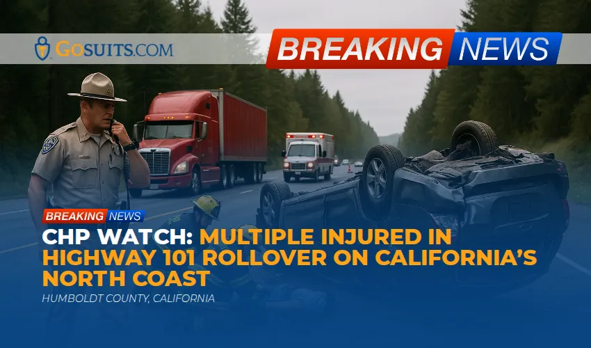
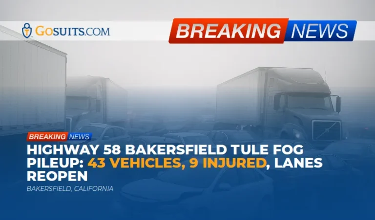
What we know about the Highway 58 pileup near Bakersfield
Just after the morning rush began on January 27, 2026, a dense bank of Tule fog rolled across Highway 58 east of Bakersfield and contributed to a chain reaction crash involving roughly 43 vehicles across the eastbound lanes. The California Highway Patrol and the Kern County Fire Department launched a mass casualty response when initial 911 calls reported dozens of vehicles, including multiple semi trucks, tangled and blocking traffic. Visibility at the scene was estimated at roughly 50 to 60 feet, which is the kind of sudden whiteout that can turn a routine commute into a life threatening emergency within seconds. Nine people suffered injuries ranging from minor to major and were taken to local hospitals. Authorities reported no fatalities as of the latest update.
All lanes of Highway 58 were shut down in both directions for hours while heavy tow units and flatbeds worked to untangle vehicles and remove debris. Caltrans District 6 reported that lanes reopened shortly after midnight on January 28 once crews confirmed the roadway was safe. For folks who drive this corridor often, this stretch is familiar. It runs east toward the Edison and Tehachapi foothills and carries a daily mix of local commuters, farm traffic, and long haul freight headed toward Mojave and Barstow. When Tule fog drops, visibility can shift from quarter mile to a few car lengths in a minute.
This pileup was not an isolated event. Throughout January, the Central Valley has seen a stubborn pattern of nighttime and morning fog from Bakersfield up through Fresno, Merced, Sacramento, and even to the Redding and Red Bluff areas, with the National Weather Service issuing repeated Dense Fog Advisories. Meteorologists have described the setup as classic Tule fog, forming with wet ground after rains, light winds, cool nights, and a strong inversion that traps moisture near the surface [1][12].
Why Tule fog is so dangerous in the Central Valley
The Central Valley’s flat basin and agricultural landscape help fog form and persist. Moisture from irrigation and recent storms lingers. Overnight, light winds and a high pressure lid allow that moisture to condense into a low cloud hugging the ground. Drivers moving at highway speeds can go from clear air into a gray wall in seconds. That sudden drop in visibility is exactly what makes chain reaction crashes so likely.
Weather and road safety researchers have long noted that reduced visibility increases the chance of multi vehicle collisions because drivers often do not slow quickly enough or increase following distance for the conditions. National roadway data show weather hazards contribute to millions of crashes each year, with fog a leading factor in reduced visibility incidents [7]. The DMV’s driver handbook also warns specifically against using high beams in fog and stresses the need to slow down, use low beams, and be ready for slow traffic or stopped vehicles ahead [6].
In our part of the Valley, fog often forms in pockets. West of downtown Bakersfield near Highway 99, around the Kern River oil fields, and along the 58 corridor toward Edison and Keene, drivers see sudden visibility swings. That patchiness tempts people to speed back up when the air clears, only to meet the next thick bank a mile later. It is why the NWS issues advisories covering large sections of Kern County on mornings like these and why CHP units often pace traffic or run traffic breaks during severe events [2][12].
Safety guidance while Dense Fog Advisories remain in effect
Officials continue to urge caution across the Central Valley while Dense Fog Advisories remain active. The National Weather Service recommends slowing significantly, using low beam headlights, and leaving extra space. If visibility becomes unsafe, pull completely off the roadway, turn on hazard lights, and avoid resting your foot on the brake pedal because the red glow can confuse approaching drivers about your position [1][2]. The California DMV echoes these tips and adds that drivers should use the right edge of the road or painted lines as a guide when lane markers disappear in thick fog [6].
- Slow down early and increase following distance. Stopping distances increase when your view of the road is compressed to a few car lengths.
- Use low beams and fog lights if equipped. High beams reflect off fog and worsen glare, reducing your ability to see hazards [6].
- Rely on lane lines and reflective markers. Keep a steady lane position and avoid unnecessary lane changes.
- Pull well off the roadway if you must stop. Never stop in a travel lane. Move to a safe shoulder or exit if possible, turn on hazards, and keep brake lights off once stopped [1].
- Expect travel delays. Give yourself extra time and consider postponing trips until advisories are lifted.
It is worth repeating that conditions can improve rapidly and then degrade again just as fast. On Highway 58, that means a driver may emerge into clearer air near Edison Highway and then plunge right back into thick fog near the foothills. Stay patient, scan well ahead, and assume stopped traffic could be around the next bend.
Road closures and where to check conditions
Caltrans QuickMap is the most up to date statewide resource for closures, incidents, chain controls, and road work. Before you head toward Tehachapi Pass, Highway 99, or the Grapevine, take a moment to check QuickMap for real time conditions like fog related cautions or collision cleanups [3]. For district level updates and maintenance activity in the southern San Joaquin Valley, Caltrans District 6 tracks projects and posts alerts for Kern, Tulare, Fresno, Madera, and Kings counties [4]. The National Weather Service Hanford office provides the latest Dense Fog Advisories, visibility reports, and forecast discussions for Kern County and the southern Valley [12].
How to get official records after the crash
After a multi vehicle collision like the Highway 58 pileup, official records matter. They help establish who responded, what traffic control was in place, time and weather details, and the sequence of events as best as investigators can reconstruct. Here are the main records people typically seek and where to start.
How to obtain the CHP collision report
Most freeway and state route crashes in Kern County are investigated by the California Highway Patrol. The responding CHP office prepares a Traffic Collision Report that documents involved parties, vehicle positions, witness statements, and contributing factors. To request a copy, CHP uses Form CHP 190. Requests can be submitted by mail or in person to the correct Area office, or via the CHP online portal when available. You will need key details like the date, time, location, and the report or incident number if you have it. Start with the CHP Collision Reports information page to confirm eligibility and the proper office [5].
If there is a fatality: coroner and autopsy information in Kern County
No deaths have been reported from this pileup. If that changes or if families need information about a separate fog related crash, the Kern County Sheriff’s Office operates the coroner function. Families can request information about identification, next of kin notifications, and autopsy findings through the coroner’s office once a case is complete. Processes and timelines vary by case type and any law enforcement investigations.
Hospital records and discharge summaries
People transported from a scene will need their discharge summary and treatment records for follow up care and any insurance claims. Hospitals in the Bakersfield area include Kern Medical, Adventist Health Bakersfield, and Memorial Hospital. Each has a medical records department that can provide instructions for requesting records, usually requiring a signed HIPAA authorization. Keep copies of any imaging, scans, and physician notes.
Other helpful documentation
- Photos and video of the scene. Even in fog, pictures of vehicle positions, road markings, and debris fields can be valuable. Consider requesting nearby traffic or CCTV footage quickly, because many systems overwrite within days.
- Caltrans closure logs. If closures or warnings were in effect, note the times. QuickMap timestamps and district updates can help corroborate conditions [3][4].
- Weather advisories and observations. Save the NWS Dense Fog Advisory relevant to the time and place. The archived advisory helps establish visibility expectations [12].
Legal context after a multi-vehicle fog crash in California
Crashes in severe weather raise tough questions. Fog does not excuse unsafe driving, but it can complicate how responsibility is assessed. California drivers have a duty to operate at a speed that is reasonable for conditions. That duty applies whether it is sunny and clear or socked in with Tule fog.
Duty to drive at a safe speed for conditions under California law
California’s Basic Speed Law states that no person may drive at a speed greater than is reasonable or prudent having due regard for weather, visibility, traffic, and the surface and width of the highway, and that no person shall drive at a speed which endangers the safety of persons or property [9]. In practice, that means a posted 65 mph is not a shield if visibility drops to tens of feet. Drivers are expected to slow down, increase following distance, and be prepared for sudden hazards. The DMV handbook reinforces this principle, advising low beams in fog, reduced speed, and extra caution at interchanges and ramps where vehicles may stop unexpectedly [6].
Commercial trucking considerations in Tule fog
Commercial drivers and their companies have additional obligations. Federal regulations require drivers of commercial motor vehicles to use extreme caution when hazardous conditions such as fog reduce visibility or traction. The rule authorizes reducing speed and, if conditions become sufficiently dangerous, discontinuing operation until the vehicle can be safely operated again [8]. In a corridor like Highway 58, which carries significant freight traffic to and from the Mojave and High Desert, this standard often becomes central in evaluating whether a truck maintained a safe speed and spacing. Bakersfield truck accident lawyers commonly look at data from electronic logging devices, dash cameras, and telematics to reconstruct speeds and braking in the seconds before impact.
Multi-vehicle insurance issues when many cars and trucks are involved
Chain reaction crashes introduce layers of insurance complexity. Dozens of drivers may each have their own insurer, policy limits, and versions of what happened. California’s courts provide a civil process for sorting fault and damages, but the early steps matter. Preserving evidence and obtaining official reports can determine whether a claim proceeds smoothly or stalls. The Department of Insurance publishes consumer guidance that can help people understand basic auto claim steps and the role of policy limits, but remember that what you say to any insurer can be used in evaluating or disputing your claim later [10][11].
Could a public entity be involved
Occasionally, claims involve allegations about the condition of public property or signage. If someone believes a dangerous condition of public property contributed to a crash, California law requires a written claim to the government entity within a short time. The Government Claims Act generally sets a six month deadline for personal injury claims against public entities, measured from the date of injury [13]. This is a specialized area with strict timelines and exceptions. The discussion here is general and not case specific.
Practical next steps for those affected
It is normal to feel shaken and overwhelmed after a fog pileup. The following steps focus on safety, health, and documentation while the details are still fresh. They are drawn from public safety guidance and best practices seen in Central Valley collisions.
- Prioritize medical care. Follow up with your primary care provider or an urgent care clinic even if you were released from the scene. Some injuries, including concussions and soft tissue damage, can surface hours or days later. Keep copies of all discharge instructions and referrals.
- Start an incident file. Save the date, time, location, weather notes, and any contact details for other parties or witnesses. Note the CHP report number once you have it and the CHP Area office that responded [5].
- Preserve vehicle evidence. Do not authorize disposal of your vehicle until essential inspections and photographs are completed. Photos of damage patterns can be crucial in multi vehicle crashes.
- Document conditions. Screenshot the relevant Dense Fog Advisory or weather observation near the time of the collision [12].
- Track lost time and expenses. Keep receipts for towing, rentals, medical co pays, and replacement items. Note missed work and any employer documentation.
For a broader look at how California trucking claims unfold and what evidence tends to carry weight in collisions involving big rigs on corridors like Highway 58, see our Legal overview for truck accident victims in California. It covers records to preserve, how motor carrier rules apply, and what to expect from insurers representing large trucking fleets.
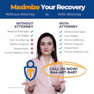
What to do before contacting any insurance company
It may be tempting to call the at fault driver’s insurer right away to get your car fixed. Slow down. In multi vehicle crashes, fault can be contested and statements are recorded. Consumer guidance from the California Department of Insurance explains what to expect from the claim process and how policy limits and coverage types can affect outcomes [10]. Before you speak with any insurer about the facts of the collision or your injuries, consider consulting with truck accident lawyers who can explain potential pitfalls and help protect your statements, especially where multiple commercial policies are involved.
In major fog pileups, commercial carriers and their insurers often deploy rapid response teams to the scene or to storage yards to secure vehicle data. That speed can put unrepresented people at a disadvantage. If you want a local perspective on freight traffic and fog risk along the Edison to Tehachapi stretch, Bakersfield truck accident lawyers will be familiar with how visibility and grade changes can affect stopping distances.
What to do next
This section highlights concrete steps and why timing matters. It is not directed at any specific person and provides general information.
- Request the CHP report as soon as it is available. Collision reports can take days to be finalized, but initiating your request early helps you avoid delays once it is released. Having the report number and the correct CHP Area office ensures it lands in the right place [5].
- Preserve electronic data and footage. Many traffic cameras and business systems overwrite video within days. Vehicle event data recorders and dash cameras may also auto delete older clips. Acting quickly increases the chances that crucial visibility and speed evidence is saved.
- Follow medical recommendations and keep records. Adhering to follow up care creates a clear record of your injuries and recovery. Gaps in treatment can raise questions later.
- Monitor Caltrans and NWS advisories. Continued Dense Fog Advisories mean future travel may require adjustments. QuickMap and NWS updates help prevent secondary incidents [3][12].
- Understand deadlines. Insurance policies have prompt notice provisions. Civil claims have statutes of limitations. Potential claims against public entities have short deadlines to file a government claim, often six months from the incident [13]. Knowing these timeframes helps avoid losing rights by waiting too long.
Commentary from Gosuits Bakersfield, California Personal Injury Attorney
Our hearts go out to everyone hurt or shaken by the Highway 58 pileup. Fog season is part of life in the southern San Joaquin Valley, but that does not make mornings like this any less frightening. This commentary is for education and general information. It is meant to help our community understand what happens after a multi vehicle crash in poor visibility and what records and safety guidance matter most.
When fog squeezes visibility down to a few car lengths, safe driving means slowing early and spacing out. The law requires speeds that are reasonable for conditions, and for commercial vehicles it requires extreme caution in hazardous weather. In a corridor that mixes commuters, farm pickups, and big rigs grinding up toward Tehachapi Pass, that duty is shared by everyone. Based on public reports, CHP and firefighters encountered near zero to 60 foot visibility at the scene and handled a complex, hours long operation to clear vehicles safely. That context is important when insurers later ask why drivers could not stop in time or who is to blame in a chain reaction.
Here is something many people do not hear up front. In big pileups, insurance companies and large motor carriers often move fast to shape the narrative. They can secure electronic data and witness statements within hours. Folks who just left the hospital or are still figuring out where their vehicle went may not even know to ask for that material. Adjusters can also sound friendly while asking questions that lock you into statements before you have seen the official report or even your medical records. Those tactics can take advantage of people’s lack of information and the normal urge to cooperate.
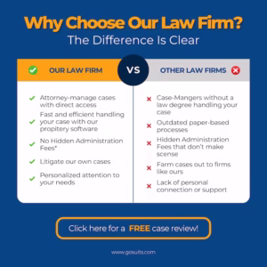
That is why a free consultation matters, especially after a freeway pileup with multiple commercial policies in play. It gives someone a chance to learn their options, understand timelines like the CHP report process or government claim deadlines, and avoid preventable mistakes with insurers. Whether a person ultimately handles things on their own or with help, being informed early often makes a real difference.
References
- Fog Safety – National Weather Service
- Dense Fog Advisory – National Weather Service
- Caltrans QuickMap – California Department of Transportation
- District 6: Central Valley and Sierra – Caltrans
- Collision Reports CHP 190 – California Highway Patrol
- California Driver Handbook: Special Driving Situations – California DMV
- Weather Impacts on Visibility – FHWA Road Weather Management
- 49 CFR 392.14 Hazardous Conditions – FMCSA
- California Vehicle Code 22350 – Basic Speed Law
- After an Auto Accident – California Department of Insurance
- Self-Help Resources – California Courts
- NWS Hanford Forecast Office – National Weather Service
- California Government Code 911.2 – Government Claims Act Deadline
- Fog and Smoke Safety Facts – California Office of Traffic Safety