- What the new pedestrian safety study found about California cities
- Cities listed as most dangerous for pedestrians
- Cities listed as safest for pedestrians
- How the list was created and why data sources matter
- Local context in Barstow and Stanton
- California pedestrian laws that shape fault and responsibility
- What to do after a pedestrian crash in Barstow, Stanton, or anywhere in California
- Where to get police reports, autopsy reports, and official records in California
- Pedestrian trends and proven safety fixes backed by government data
- Legal insight: potential civil liability in pedestrian crashes
- Insurance and claims considerations after a pedestrian injury or fatality
- Community safety actions that can reduce crashes
- Action steps to take now
- Commentary from Gosuits Barstow, California Personal Injury Attorney
- References
What the new pedestrian safety study found about California cities
In late 2025, a California law firm compiled national rankings of the safest and most dangerous U.S. cities for pedestrians using per capita crash data from 2020 to 2023. The study highlighted five California cities among the safest and identified two California communities among the most dangerous. The rankings were based on pedestrian crashes per 100,000 residents, with the authors pointing to infrastructure, traffic volume, and enforcement as major drivers of risk and safety.
Although the rankings came from a private analysis, the underlying data sources are widely used in transportation safety: the Federal Highway Administration, the National Highway Traffic Safety Administration’s Fatality Analysis Reporting System, and U.S. Census Bureau population estimates [1] [2] [3]. These sources inform most government safety programs in California and nationwide.
Why does this matter locally? Because these findings reflect what many community members already see day to day. In places like Barstow, where I-15 and I-40 funnel heavy traffic through the Mojave Desert, and Stanton, home to high-traffic corridors that connect Anaheim and Garden Grove, the mix of fast-moving vehicles, limited crossings, and nighttime visibility challenges can set the stage for serious pedestrian harm.
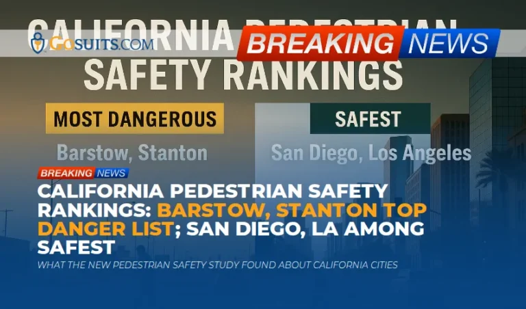
Cities listed as most dangerous for pedestrians
The study listed the following as the most dangerous U.S. cities for pedestrians by crashes per 100,000 residents. Two California cities appear here:
- Hempstead, New York at 117.5
- Hingham, Massachusetts at 94.2
- Decatur, Georgia at 73.5
- Stanton, California at 72.8
- Barstow, California at 64.3
- Gallup, New Mexico at 63.9
- Pleasantville, New Jersey at 57.4
- Camden, New Jersey at 55.7
- Memphis, Tennessee at 50.7
The authors attributed high rates to factors such as high-speed roadways, limited pedestrian infrastructure, and heavy vehicle volumes. While each city’s context is different, California’s appearance on this list underscores a statewide challenge: much of our roadway network was built for vehicle throughput rather than people walking, particularly in older suburban corridors and desert highway hubs.
Cities listed as safest for pedestrians
On the other end of the spectrum, the study found extremely low per capita pedestrian crash rates in several large cities, with California again featured prominently:
- San Diego, California at 0.14
- Guilford, North Carolina at 0.18
- Los Angeles, California at 0.18
- San Francisco, California at 0.36
- Sacramento, California at 0.37
- Macomb, Michigan at 0.45
- Modesto, California (rate not listed in the summary)
- Hernando, Florida
- Maui, Hawaii
- Broken Bow, Oklahoma
These results may surprise people who associate larger cities with higher risks. Large cities can achieve lower rates when they combine protected crossings, slower design speeds, better lighting, and strong enforcement. Anyone who has walked in downtown San Diego near the Gaslamp Quarter or around Balboa Park has probably seen treatments like high-visibility crosswalks, leading pedestrian intervals, and traffic-calmed streets that reduce turning conflicts. These are the very countermeasures FHWA and local agencies have promoted to reduce pedestrian harm [2].
How the list was created and why data sources matter
According to the report’s methodology, the team gathered pedestrian crash counts from FARS and other local or state reports that feed into federal systems, then normalized by population using U.S. Census estimates. That approach is common because it allows comparisons across cities of different sizes, and it aligns with how safety practitioners evaluate progress or emerging risks [1] [3].
Still, numbers alone can miss context. For example, a small city with a handful of serious incidents might show a high per capita rate even though the absolute number of crashes is modest. On the other hand, very large cities can have lower per capita rates but still experience a high number of serious injuries that affect many families. That is why federal guidance encourages combining quantitative analysis with on-the-ground understanding of street design, land use, enforcement, and behavior [2].

Local context in Barstow and Stanton
Barstow sits at the crossroads of I-15, I-40, and historic Route 66. The city’s desert geography, long stretches of wide roadways, and substantial freight and tourism traffic can create visibility and speed challenges. Evening foot traffic around shopping centers, hotels by the interstate, and the Outlets at Barstow often mixes with drivers who are fatigued from long drives. It is a combination the community knows too well: fast corridors, long crossing distances, and inconsistent lighting can put people on foot at risk, especially at night or during peak travel holidays.
Stanton lies in northern Orange County and includes segments of Beach Boulevard, Katella Avenue, and Anaheim–Stanton border corridors that can carry regional traffic toward Anaheim, Garden Grove, and the 22 and 5 freeways. Anyone who has tried to cross Beach Boulevard near major retail knows how daunting it can be. Multiple lanes, turning movements, and high traffic volumes mean that walking to a grocery store, school, or park can feel risky without protective features like refuge islands, median treatments, or signal timing that favors people walking.
The study’s findings resonate with these day-to-day realities. They also track with state and federal guidance that calls for lower speeds where people walk, high-visibility crossings, and lighting upgrades that help drivers see people earlier at night [2].
California pedestrian laws that shape fault and responsibility
California law sets both rights and duties for drivers and pedestrians. A few foundational points guide how crash responsibility is analyzed:
- Drivers must yield to pedestrians in marked crosswalks and at unmarked crosswalks at intersections. California Vehicle Code section 21950 requires drivers to exercise due care and slow down or stop as needed for pedestrians crossing within crosswalks, while pedestrians must also use due care for their own safety [9].
- Crossing outside crosswalks is restricted between two adjacent signalized intersections. California Vehicle Code section 21955 limits midblock crossings in certain controlled areas, though the details depend on intersection control and signage [10].
- Freedom to Walk Act (AB 2147). This statewide reform that took effect in 2023 narrows when pedestrians can be cited for jaywalking. Enforcement should focus on crossings that pose an immediate hazard rather than technical violations that are not dangerous in context [11]. For a plain-language walkthrough of what this change means day to day, see jaywalking legal california freedom act.
Because California uses comparative negligence, fault can be shared based on all circumstances. Street design may also matter. For example, if a crossing is unreasonably long, poorly lit, or lacks basic protections, that context is often part of how liability is evaluated in a civil claim. It is one reason thorough documentation of the scene is important immediately after a crash.
What to do after a pedestrian crash in Barstow, Stanton, or anywhere in California
Crashes are chaotic, and it is easy to miss steps. Here is a practical, people-first sequence to consider. It is not legal advice, just general information based on how claims are typically evaluated in California.
- Call 911 and get medical care first. Even if injuries seem minor, internal injuries and head trauma may not show symptoms immediately. Keep all discharge papers and imaging results.
- Ensure a police report is made and note the investigating agency. In Barstow, many roadway crashes are handled by the California Highway Patrol, while local streets may involve Barstow Police. In Stanton, patrol and investigations typically involve Orange County Sheriff’s Department. The agency name will determine where to request the official report later.
- Collect scene evidence if safe. Photos of the roadway, vehicle positions, skid marks, debris, damaged clothing, and shoe scuffs near crosswalks can prove critical. Capture surrounding lighting, traffic signals, and nearby businesses that might have CCTV.
- Identify witnesses and businesses with cameras. Ask for names and phone numbers. Jot down the exact storefronts and addresses. If there are transit buses nearby, note route numbers and agencies for potential video requests.
- Preserve what you were wearing and using. Do not wash clothing or shoes. Save any broken glasses, phones, mobility aids, or stroller parts.
- Document pain and limitations. Keep a daily log of symptoms, missed work, and tasks you cannot perform. This helps show real-world impact.
- Consult an attorney before speaking to insurance companies. Many people call the at-fault driver’s carrier right away, but what you say can be used against you. A brief consult helps you understand rights, coverage options, and typical insurer tactics. Seasoned car accident lawyers who handle pedestrian cases can help protect your claim from the start.
Where to get police reports, autopsy reports, and official records in California
Official documents are often essential in injury and wrongful death claims. Agencies differ by location and roadway jurisdiction, so it helps to know where to look and what to ask for. The references below point to the correct government offices and request portals.
Police and collision reports
- California Highway Patrol (CHP). Many crashes in Barstow, on interstates, or on state routes are investigated by CHP. Request the collision report and any diagrams or supplemental narratives through CHP’s collision records process [4]. Ask specifically for all attachments, including any photographs or scene measurements, if available.
- City police departments and county sheriffs. For local street crashes, check the city police department or the county sheriff that patrols your area. In Stanton, the Orange County Sheriff’s Department handles policing services, while Barstow maintains its own police department for city streets. Use the report number from the officer’s card when making your request.

Medical examiner and coroner records after a fatal crash
- San Bernardino County Sheriff Coroner Division for incidents in Barstow or elsewhere in the county. You can request coroner reports and, when available, toxicology reports. Timelines depend on the case status [5].
- Orange County Sheriff’s Department Coroner Division for incidents in Stanton or elsewhere in the county. Ask about coroner protocols, identification procedures, and report request steps [6].
- Los Angeles County Department of Medical Examiner if an incident or transfer occurs in LA County. They maintain an online case search and request process for reports and certificates [7].
- San Diego County Medical Examiner for fatalities within San Diego County. The office provides report request instructions and release policies [8].
Other items to consider requesting
- 911 audio and Computer Aided Dispatch (CAD) logs. These can confirm timelines and witness statements.
- Traffic signal timing sheets and maintenance logs. These records can show whether a leading pedestrian interval, walk phase timing, or flashing yellow arrow might have been in effect near the time of the crash.
- Public records under California law. The California Public Records Act allows requests for many non-privileged government records. Ask for retention timelines so you can act before data is purged [12].
Pedestrian trends and proven safety fixes backed by government data
Federal and state data continue to show persistent risks for people walking. National systems like FARS enable agencies to analyze where, when, and how pedestrians are harmed, and to develop countermeasures that save lives [1]. Public health agencies underscore the severity of pedestrian injuries, particularly in nighttime conditions and on higher speed roads where survivability drops dramatically [13].
Transportation agencies have identified a set of proven safety countermeasures. These include better lighting for nighttime visibility, high-visibility crosswalks, median refuge islands, curb extensions that shorten crossing distance, leading pedestrian intervals that give people a head start before turning vehicles move, and roadway designs that reduce speeds where people walk. Agencies also promote a Safe System Approach that layers engineering, enforcement, and education while recognizing human mistakes will happen and should not result in fatal outcomes [2] [14].
Low-rate cities in California provide practical examples. San Diego and Los Angeles have expanded signal timing treatments, daylighting at intersections, and protected crossings in key corridors. San Francisco’s neighborhood traffic calming and San Jose’s focus on speed management show what is possible when cities align design, operations, and enforcement.
Legal insight: potential civil liability in pedestrian crashes
From a civil perspective, several categories of parties can bear responsibility, depending on the facts:
- Drivers and vehicle owners. Driver inattention, inappropriately high speed for conditions, failure to yield in crosswalks, impaired driving, or hazardous turns are common sources of fault. Vehicle owners can bear liability under permissive use rules.
- Employers and commercial entities. If a delivery driver or ride-hailing driver caused harm within the scope of their work, the company may share responsibility under vicarious liability principles.
- Public entities. In some cases, a claim may involve allegations of a dangerous condition of public property, such as inadequate lighting or an unreasonably unsafe crossing. These claims require prompt notices and have shorter deadlines. The details are very fact specific and depend on design standards, maintenance records, and whether a reasonable fix was feasible.
- Product or maintenance issues. Rarely, faulty vehicle equipment or negligent repair can play a role in a crash scenario, which can broaden who is potentially at fault.
Importantly, pedestrians retain claims even when insurers argue shared responsibility. Comparative negligence allocates percentages of fault. Thorough evidence collection often makes the difference between an insurer’s quick denial and a fair evaluation of what actually happened at the curb, in the crosswalk, or in the midblock environment.
Insurance and claims considerations after a pedestrian injury or fatality
Insurance can be complex in pedestrian cases because multiple policies may apply:
- Driver’s liability policy. This is typically primary for bodily injury caused by driver negligence.
- Uninsured and underinsured motorist coverage (UM/UIM). If the at-fault driver lacks adequate coverage, a pedestrian’s own auto policy may step in.
- Medical payments coverage. Some auto policies provide limited medical benefits regardless of fault.
- Employer policies and commercial coverage. If the driver was working, commercial coverage may be implicated.
- Wrongful death claims. Certain surviving family members may have claims arising from a fatal crash, with separate survival actions for pre-death pain and suffering in specific circumstances.
Before calling any insurance company, consult an attorney. Adjusters often ask for recorded statements early, and even casual comments can be used to dispute liability later. An initial consultation helps clarify coverage, deadlines, and what documentation strengthens a claim.
Community safety actions that can reduce crashes
Local leaders and residents across Barstow, Stanton, and neighboring communities can push for targeted improvements. Many of these fixes are low cost and backed by federal guidance:
- Light up crossings and corridors. Nighttime lighting raises detection distance and reaction time. Prioritize areas with evening foot traffic, especially near retail, transit stops, and schools.
- Shorten crossing distances. Curb extensions and median refuge islands reduce exposure time and simplify decision making for people walking.
- Give pedestrians a head start. Leading pedestrian intervals reduce turning conflicts, particularly on multi-lane arterials and at intersections with heavy turning volumes.
- Manage speed where people walk. Design speeds matter more than posted limits. Narrowed lanes, speed cushions, and road diets can tame fast corridors without crippling access.
- Add high-visibility markings. High-contrast crosswalks and advance stop bars cue drivers to expect pedestrians.
- Fill sidewalk and lighting gaps. Especially in desert communities where distances are long, predictable lighting and continuous sidewalks are basic safety infrastructure.
These treatments are at the heart of FHWA’s proven safety countermeasures and Safe System Approach, which emphasize forgiving streets that prevent severe outcomes even when someone makes a mistake [2] [14].
Action steps to take now
This section is about timing and preparation. Crashes leave a paper trail that can disappear quickly. Acting promptly preserves your options.
- Request the correct police or CHP report as soon as you have the report number. Collision reports, photos, and diagrams can be purged or archived. Ask for all attachments and supplements.
- Set reminders for coroner or medical examiner timelines. Autopsy and toxicology reports often take weeks or months. Write down the case number and follow up periodically to avoid delays.
- Preserve private video and witness details within days. Many businesses overwrite security footage in a week or less. A prompt, polite request with the exact date and time can make all the difference.
- Document injuries, treatment, and life impacts from day one. Save every bill, mileage to appointments, and notes about pain, sleep disruption, and missed responsibilities. You will need this later.
- Do not post details on social media. Insurers may review public posts to dispute injury severity or timelines.
- Speak with a qualified attorney before any recorded statement to insurance. A short consult helps you understand coverage options, typical insurer questions, and how statements can be used.
- Calendar civil and public records deadlines. Claims against public entities have shorter windows. Public records, like 911 audio, may have limited retention. Acting early protects your ability to obtain key evidence.

Commentary from Gosuits Barstow, California Personal Injury Attorney
We are thinking of everyone in the communities named in this study, particularly families who have lost loved ones or are recovering from serious injuries. This article is for general information and educational purposes. Every situation is different, and the most helpful next step is to have your specific facts reviewed.
From our perspective, the study’s focus on both dangerous and safe cities tells a clear story. Road design and operations matter. You can feel it when crossing Beach Boulevard in Stanton or walking along Route 66 corridors in Barstow. Long crossings, turning conflicts, and low nighttime visibility raise risk. The cities that are trending safer have invested in signal timing, lighting, and speed management. The takeaway is not that safety is fixed, but that targeted steps can move the needle.
We also see how insurance companies and large corporations capitalize on uncertainty. Shortly after a crash, adjusters may request recorded statements, hunt for minor inconsistencies, or point to technicalities like midblock crossings without acknowledging design realities such as poor lighting or excessive crossing distances. Without guidance, people can inadvertently undermine their own claims, even when the crash circumstances point to clear hazards drivers should have anticipated.
A free consultation can level the playing field. It helps clarify coverage, identify evidence that needs immediate preservation, and map out realistic timelines. That initial conversation is often where families learn how comparative fault is argued, how roadway design can be documented, and how to navigate the many moving parts of a claim with confidence.
References
- Fatality Analysis Reporting System (FARS) – NHTSA
- Proven Safety Countermeasures – Federal Highway Administration
- Population Topics – U.S. Census Bureau
- Collision Records Requests – California Highway Patrol
- Coroner Division – San Bernardino County Sheriff’s Department
- Coroner Division – Orange County Sheriff’s Department
- Medical Examiner – County of Los Angeles
- Medical Examiner’s Office – County of San Diego
- California Vehicle Code 21950 – Leginfo
- California Vehicle Code 21955 – Leginfo
- AB 2147 Freedom to Walk Act – Leginfo
- California Public Records Act Overview – Office of the Attorney General
- Pedestrian Safety – Centers for Disease Control and Prevention
- Safe System Approach – Federal Highway Administration